ID photo software
Сamera control software
ID card software
info@akond.net, akondsales@gmail.com
| 
| | |
User stories >> Remote sensing
|
 |
inPhoto Oly application:
Remote sensing for evaluating vegetation
|
This story is the courtesy of Mr. David Jones, MS Research Associate, Texas Agriculture Experiment Station, Bushland, TX 79012, USA. Mr. David Jones won a free copy of inPhoto Oly camera control software (discontinued from June, 2006. inPhoto Oly software is replaced by inPhoto Capture designed for full computer control of Canon digital cameras). trial version. . Please refer to giveaway action for more details.
|
|
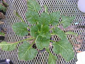
Figure 1. Over head image taken with
Olympus C-765UZ camera using inPhoto software.
|
Remote sensing is a general term for a variety of methods used to acquire and analyze measurements of an object without physical contact between the measuring device and the object. It is frequently used for evaluating vegetation over large areas at a relatively low cost.
The relationship between crop characteristics and remote spectral observations, obtained by measuring canopy light reflectance, is the foundation for remote sensing in agriculture.
In these images (Figures 1 and 2) and for future work, digital image data were collected using an Olympus C-765 digital camera.
Refer to description of inPhoto Capture software (Canon camera control) for details on its functionality.
|
|
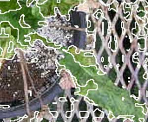
Figure 2. Processed images indicating lesions on leaf.
|
Ideally, the images would be uncompressed tagged image file format (tiff) images. These images are highly compressed 640x480.
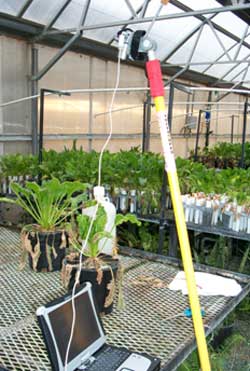
Tiff format is preferred so that data in pixels would not be distorted in compression. The camera was mounted on a pole extended over the sugar beet plant in the greenhouse (Figure 3).
Each image was imported into APS Assess software for analysis. Consistent threshold levels were set to identify soil, leaf area, and lesion area. The software calculated percent total leaf area and percent lesion based on the number of pixels that was considered leaf and lesion. Percent soil and percent green leaf could then be calculated in a spreadsheet program.
The purpose of using digital image analysis in this study is for quantifying lesions in the plant leaves. It is commonly done by visual assessments, however, with the overhead view and using image analysis, it is a great way to quantify lesions in an unbiased manner.
|
|
Figure 3. Olympus camera mounted on a pole for overhead image capture
|
In the past we used the timer on the camera to give us time to raise the pole up and take the picture. This method is often awkward and unreliable. Occasionally, when I came from the field, I would discover one or more of the images were out of focus or not on target. It is usually impossible or at least difficult to recollect data since the data in the images is somewhat time sensitive.
With inPhoto, we can actually see what we are taking a picture of when data is being captured. With the full version of inPhoto, we will be able to save time, money and the hassle of discovering bad images too late.
|
| | |
|
|